
Ha Giang Loop Map: Route, Stops, and Planning Tips
Ha Giang is one of the most beautiful places in Vietnam. In the far north of the country.
The Ha Giang Loop is a road trip through the mountains. Famous for stunning views and wild landscapes. Many travelers call it the best road trip in Southeast Asia.
This guide will help you plan your trip. You will learn about the route, the main stops, and useful tips.
What Is the Ha Giang Loop?
The Ha Giang Loop is a circular mountain road. It starts and ends in Ha Giang City.
The full loop is about 350 kilometers. Most travelers complete it in 3 to 4 days. Some people take 5 to 6 days to enjoy it more slowly.
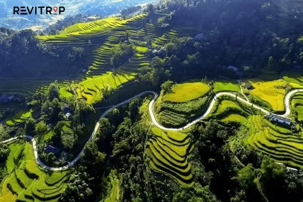
The road passes through dramatic mountain scenery. You will see deep valleys, high passes, and rice terraces. The landscape changes a lot along the way. One of the most scenic drives in all Asia.
The Main Route
The loop has two main directions. You can go clockwise or counterclockwise. Most travelers go counterclockwise. This means you start by heading north toward Quan Ba.
Here is the basic route:
Ha Giang City → Quan Ba → Yen Minh → Dong Van → Meo Vac → Du Gia → Ha Giang City
This route covers the most famous spots. It takes you through the Dong Van Karst Plateau. This area is a UNESCO Global Geopark.
Main Stops on the Loop
Ha Giang City
This is the starting point of the loop. Ha Giang City is a small and quiet town.
You can get your motorbike here. You can also stock up on supplies. Most guesthouses in the city can help you plan the route.
Quan Ba – Heaven’s Gate
Quan Ba is about 45 kilometers from Ha Giang City. The drive takes around 2 hours.
The highlight here is Heaven’s Gate. A mountain pass with wide views.
You can see the Twin Mountains below. These are two round hills that rise from the valley. The view is one of the most photographed in Ha Giang.
Yen Minh
Yen Minh is a small town on the way to Dong Van. Many travelers stop here for lunch or to spend the night. The road from Quan Ba to Yen Minh passes through pine forests. A peaceful and beautiful drive.

Dong Van
Dong Van is one of the most important stops on the loop. It has a charming old quarter with ancient houses. The market here is lively and colorful.
You can try local food and shop for handmade goods. The Dong Van Karst Plateau is nearby. The rocky landscape here is unique and dramatic.
Ma Pi Leng Pass
This is the most famous part of the Ha Giang Loop. Ma Pi Leng Pass is a narrow mountain road. It sits high above the Nho Que River. The views are breathtaking.
They carved the road into the cliff. Looking down, you can see the river far below. A bright turquoise color. This is a must-see on the entire loop.
Meo Vac
Meo Vac sits at the end of Ma Pi Leng Pass. A small mountain town.
The Sunday market here is extremely popular. Local ethnic minority people come to buy and sell goods. A great place to learn about local culture. The town has simple guesthouses and good local food.
Du Gia
Du Gia is on the return leg of the loop. This stop is less crowded than other stops.
A beautiful waterfall is near the village. The scenery here is lush and green. The road back to Ha Giang City from Du Gia is winding but scenic.
How to Travel the Loop
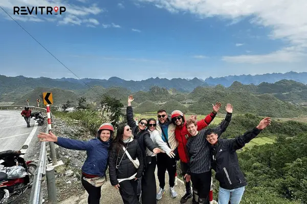
Most travelers rent a motorbike in Ha Giang City. A semi-automatic bike is popular for beginners. An experienced driver can also take you on the back of a motorbike. People call this an “Easy Rider” tour.
The road can be narrow and steep in some parts. Drive slowly and carefully. Fuel stations are not always easy to find. Fill up your tank whenever you can.
Best Time to Visit
Ha Giang has different beauty in every season.
October and November are the most popular months. The buckwheat flowers bloom during this time. The fields turn pink and purple. A stunning sight.
March and April are also beautiful. Rape flowers bloom in yellow along the roads.
The rainy season runs from May to August. Roads can be slippery and foggy. Travel is harder during this time.
Planning Tips
Start early each day. The mountain roads take more time than they look on a map. Mornings are often clearer. Fog and clouds can come in the afternoon.
Bring warm clothes. The mountains are cool, especially at night. Even in summer, evening temperatures can drop.
Book guesthouses in advance during peak season. Dong Van and Meo Vac fill up fast in October and November.
Bring cash. ATMs are not common along the loop. Ha Giang City is the best place to withdraw money before you leave.
Wear a helmet. The roads are beautiful but they are also risky. Safety comes first.
Respect local culture. Many villages along the loop are home to ethnic minority groups. Ask before taking photos of people.
Final Thoughts
The Ha Giang Loop is a once-in-a-lifetime experience. The scenery is raw and powerful. The road takes you through some of the wildest land in Vietnam. With good planning, the trip is safe and unforgettable.
Take your time. Enjoy every kilometer. Ha Giang will stay in your memory for a long time.
FAQ
The Ha Giang Loop is a circular mountain road in northern Vietnam. It starts and ends in Ha Giang City and is famous for its dramatic landscapes and scenic views.
The full Ha Giang Loop is about 350 kilometers long. Most travelers complete it in 3 to 4 days, though some take longer to explore more slowly.
Most travelers go counterclockwise, starting toward Quan Ba. This direction offers better views and a more natural flow of major stops.


