Ca Mau Cape marks the end of Vietnam’s mainland. This is the southernmost point of the country, where the East Sea and the Gulf of Thailand converge at a single horizon. Standing at the national coordinate marker here carries a weight that no photograph fully captures. The salt wind comes from two directions. The ocean stretches in every direction. Behind you, the entire length of Vietnam extends northward for nearly 2,000 kilometers. For many Vietnamese travelers, reaching Ca Mau Cape is a lifetime ambition. For international visitors, it is one of the most distinctive geographical experiences the country offers. This guide covers everything you need to know before you go.
1. What Is Ca Mau Cape?
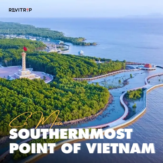
Ca Mau Cape, known in Vietnamese as Mui Ca Mau, is the southernmost point of Vietnam’s mainland territory. It sits within Ca Mau province at the tip of the Mekong Delta, where the land gradually dissolves into a network of mangrove channels and tidal mudflats before meeting open water on two sides.
The cape holds both geographical and symbolic significance. It marks the southern end of the S-shaped Vietnamese coastline that stretches from Lang Son province in the north to this single point in the south. Every map of Vietnam points to it. Every school textbook references it. Reaching Ca Mau Cape is, for many Vietnamese people, an act of completing something important.
“Ca Mau Cape is not just a point on a map. It is the place where the country ends and the ocean begins. Standing there makes you feel the full length of Vietnam in a way that no other place can.”
2. Ca Mau Cape National Park and the Biosphere Reserve
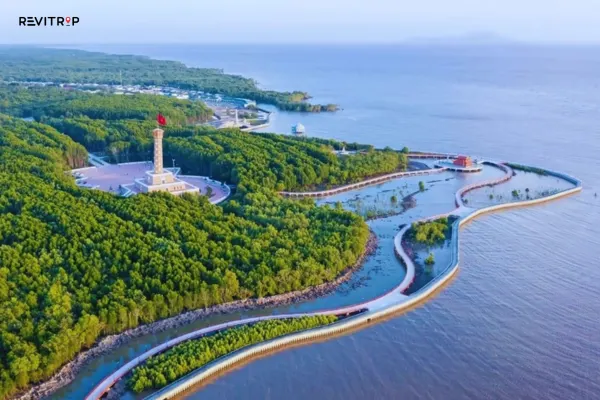
Ca Mau Cape sits within Mui Ca Mau National Park, one of three protected areas that together form the Mui Ca Mau World Biosphere Reserve. UNESCO granted this reserve recognition in 2009, acknowledging the ecological significance of the coastal mangrove system that surrounds and protects the cape itself.
The national park covers more than 41,000 hectares of land and sea. Within that area, the mangrove forest represents one of the largest and most intact coastal mangrove systems remaining in Southeast Asia.
The forest actively builds new land along the western coastline, advancing the shoreline into the Gulf of Thailand at a measurable rate each year.
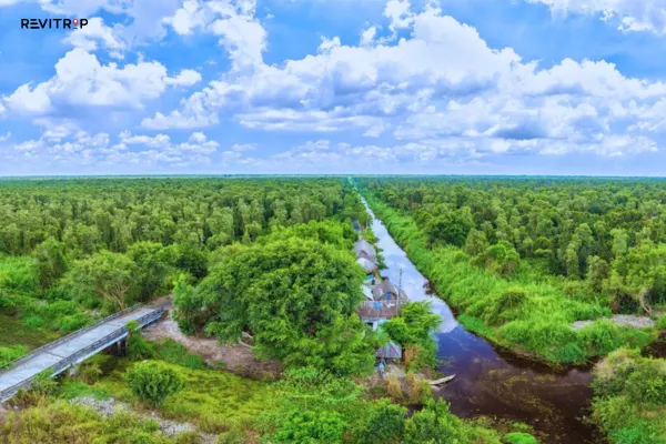
The Mangrove Ecosystem
The mangrove forest around Ca Mau Cape performs several critical ecological functions. It stabilizes the coastline against erosion and storm surge. It supports a diverse community of waterbirds, reptiles, and mammals that depend on the tidal zone environment.
Key ecological facts:
- Over 30 mangrove species grow within the national park boundary
- The forest supports more than 100 bird species including several regionally significant waterbirds
- Marine species including mud crabs, tiger prawns, and multiple fin fish species use the mangrove channels as breeding and feeding habitat
- The western coastline advances approximately 50 to 80 meters per year as the mangrove root system traps sediment
The Coordinate Marker
The national coordinate marker at Ca Mau Cape is the symbolic centerpiece of any visit. The marker sits at the precise southernmost point of the Vietnamese mainland and carries the official latitude and longitude coordinates of the cape. Visitors photograph themselves at the marker as a record of having reached the end of the country.
The marker stands at the edge of the mangrove zone where land meets tidal flat. At certain tide levels, the path to the marker crosses shallow water. At low tide, the mudflats extend outward and the full geography of the cape becomes visible in both directions.
3. How to Get to Ca Mau Cape
Reaching Ca Mau Cape requires more planning than most tourist destinations in Vietnam. The cape does not sit on a road. Access combines overland travel to the departure point with a boat journey through the mangrove river system.
Getting to Ca Mau Province First
The journey begins in Ca Mau city. From Ho Chi Minh City, the main options are:
- Domestic flight to Ca Mau Airport, approximately one hour
- Overnight sleeper bus from Mien Tay Bus Station, arriving the following morning
- Private car via National Highway 1A, approximately eight hours
For a full breakdown of every transport option into the province, our Ca Mau travel guide covers each route in detail. Our dedicated guide on how to get to Ca Mau is also worth reading before you book transport.
Getting from Ca Mau City to the Cape
From Ca Mau city, the journey to the cape follows one of two main routes:
Route 1: Road to Dat Mui, then boat to the cape
- Travel by road from Ca Mau city to Dat Mui pier, approximately 100 km
- Take a short boat transfer from Dat Mui to the cape landing point
- Total travel time from Ca Mau city: approximately 3 to 4 hours each way
Route 2: Full boat journey via Nam Can
- Travel by road to Nam Can town
- Continue the remainder of the journey entirely by boat through the mangrove river system
- This route takes longer but delivers a more immersive experience through the tidal forest
“The boat journey to Ca Mau Cape through the mangrove channels is not just transport. It is the beginning of the experience. The river narrows, the canopy closes in, and by the time you arrive, you already feel like you have reached somewhere genuinely remote.”
For booking organized day tours to Ca Mau Cape that handle all transport logistics, GetYourGuide lists a range of Ca Mau and Mekong Delta experiences with flexible departure options.
4. What to See and Do at Ca Mau Cape
Arriving at Ca Mau Cape opens up several distinct experiences within the national park and the surrounding area.
The Coordinate Marker and Viewing Platform
The national coordinate marker is the first stop for every visitor. The viewing platform adjacent to it provides an elevated perspective over the tidal flat and mangrove zone. From the platform, the convergence of the two seas becomes visible on clear days, with the color and texture of the water noticeably different on the east and west sides of the cape.
Sunrise and Sunset Viewing
Ca Mau Cape is one of the only places on Vietnam’s mainland where you can watch the sun rise over one sea and set into another on the same day. Sunrise comes from the east over the East Sea. Sunset drops into the Gulf of Thailand to the west. Timing an overnight stay at one of the guesthouses near Dat Mui to catch both events is strongly recommended.
Best positions for sunrise and sunset:
- The viewing platform at the coordinate marker for both events
- The elevated walkways through the mangrove forest for framed sunrise shots
- The western shoreline of the cape for unobstructed Gulf of Thailand sunsets
Mangrove Forest Walking Trails
Elevated wooden walkways run through sections of the mangrove forest adjacent to the cape landing area. These trails allow visitors to move through the mangrove ecosystem at close range without disturbing the root system or tidal zone below. The experience of walking above the mangrove canopy is available nowhere else in the Mekong Delta region.
Boat Tours Through the Mangrove Channels
Narrow wooden boats navigate the canal system within the national park, moving through corridors of mangrove forest where the canopy meets overhead and the water runs calm beneath the trees. These tours depart from the cape landing area and from Dat Mui pier. They represent one of the most direct ways to experience the ecological character of the cape and its surrounding forest.
For bookable boat tours and day trip packages to Ca Mau Cape, Klook lists a range of options that can be reserved before departure.
Dat Mui Village
Dat Mui is the small settlement nearest to Ca Mau Cape and the main service hub for visitors. A fresh seafood market operates here from early morning, selling mud crabs, prawns, and fish caught in the surrounding waters. Small guesthouses and restaurants provide overnight accommodation and meals for travelers who want to spend more than a single day at the cape.
The village has a quiet, end-of-the-road character that reflects its geographical position. Most visitors pass through on a day trip from Ca Mau city. Those who stay overnight discover a version of the cape that day visitors never see.
5. Best Time to Visit Ca Mau Cape
Choosing the right season makes a significant difference to the Ca Mau Cape experience. For a full seasonal breakdown of the province, our guide on the best time to visit Ca Mau covers every month in detail.
Dry season (December to April):
- Best weather conditions with low humidity and consistent sunshine
- Boat tours run without weather interruptions
- Clear skies produce the best sunrise and sunset photography conditions
- Accommodation at Dat Mui books faster during this period, particularly around Tet
Rainy season (May to November):
- Water levels rise and the mangrove ecosystem reaches its most vivid state
- Deeper sections of the forest become accessible by boat
- Afternoon rain showers are typical but mornings remain mostly clear
- Fewer visitors make the experience more intimate
The shoulder months of November and December offer a practical balance. The rainy season is ending, water levels remain relatively high, and the dry season crowds have not yet arrived.
6. Practical Tips for Visiting Ca Mau Cape
A few preparation habits make the trip smoother regardless of which season you visit.
Before you go:
- Book accommodation in Dat Mui at least two weeks in advance during the dry season
- Confirm transport and boat tour arrangements before leaving Ca Mau city
- Carry sufficient cash as ATM access does not exist at the cape or in Dat Mui
- Check our guide to scams in Vietnam before traveling through busy transit points en route
At the cape:
- Wear light, breathable clothing and bring insect repellent for the mangrove trail sections
- Start the boat journey early to arrive at the cape before midday heat peaks
- Bring a fully charged camera or power bank as charging options at the cape are limited
- Allow at least half a day at the cape itself, not including travel time
- Respect the national park regulations around waste disposal and wildlife interaction
Getting back:
- Confirm your return boat departure time before your outbound boat leaves
- Allow buffer time when connecting back to Ca Mau city for onward transport
- If combining the cape with other province attractions, our full things to do in Ca Mau guide helps structure the wider itinerary
Final Thoughts: Ca Mau Cape Is Worth Every Kilometer
Ca Mau Cape is the kind of destination that stays with you. The coordinate marker, the two-sea horizon, the mangrove channels, and the quiet of Dat Mui village at dusk all add up to an experience that feels genuinely significant. It is not the easiest place to reach in Vietnam. That is exactly the point.
Plan two days minimum at the cape to do it properly. Arrive in the late afternoon for a first sunset. Wake early for the sunrise the following morning. Take a boat tour through the mangroves before the midday heat sets in. Then eat mud crab at the market in Dat Mui before heading back to Ca Mau city. That sequence covers the essential range of what Ca Mau Cape offers. For everything else you need to plan the full province trip, explore tours and experiences through GetYourGuide and find the right itinerary for your journey south.
Ready to reach the end of Vietnam? Browse our complete Ca Mau destination guide for transport tips, top attractions, and everything you need to plan your trip to the southernmost province!
FAQs
Ca Mau Cape is the southernmost point of Vietnam’s mainland, where the East Sea and the Gulf of Thailand meet. It sits inside Mui Ca Mau National Park, part of a UNESCO biosphere reserve. For Vietnamese travelers, reaching the cape is a symbolic act of completing the length of the country. For international visitors, it offers a rare geographical experience found nowhere else in Vietnam.
Fly or take a sleeper bus to Ca Mau city first. From there, travel by road to Dat Mui pier and take a short boat transfer to the cape. Alternatively, take a full boat journey via Nam Can for a more immersive mangrove river experience. Total travel time from Ho Chi Minh City is roughly one full day each way.
Two days gives the best experience. Arrive in the late afternoon for sunset, stay overnight at Dat Mui, and wake early for sunrise over the East Sea. A morning boat tour through the mangrove channels completes the visit before returning to Ca Mau city. A single-day visit is possible but misses both the sunrise and the quieter atmosphere of the cape after day-trip crowds leave.